The Maze: A Vacation with Glenn in 1987
This story has been told in book form available on Blurb. It has a much larger range of photos from the trip and may be purchased here...
Recently on my last trip to the US I stopped to stay with my dad and Joanne. My dad and I dug through the archives of Glenn's photos and I retrieved some old slides of his. The ones I was particularly interested in were from a vacation we took together in November of 1987, about 20 years ago.
We traveled to Southern Utah in Canyonlands National Park. What Edward Abbey referred to in an essay Terra Incognita: Into the Maze (Desert Solitaire, 1968). Indeed, this was the inspiration for the trip we took. Ever since having read this essay I was captivated by the description and had to see it for myself. Being as such I will literate our journey's description with Abbey's words. Interestingly his book was published a further twenty years earlier than our visit.
(The photos are ones that Glenn and I took with his Olympus OM2 camera. He also had Grandma'a Hassleblad. I have scanned the 35mm slides and touched them up for this blog entry. It is sometimes hard to remember who took each photo but Glenn figures as the subject in many and so I think I took most of the photos.)
As Ed says first you have to get there.
Glenn and I traveled from Flagstaff and myself from Tucson the day before that. It is a long drive and more remarkable is the time it took once we left pavement. We drove fast at least 60mph on that dirt road and it seemed hours. Once we left pavement it was time to break out the Coors. The ground zipped past us and we saw more than one rattlesnake on the road as we had headed for the Flint Trail. Now before the Flint Trail there is a small Ranger station with one Ranger who we labeled Ranger Death-breath on account of his halitosis. Now Death-breath felt obligated to warn us of the difficulties on the Flint Trail. We politely registered but once we got back in the car we dismissed his warnings with alcohol-fueled bravado, popped in a Hank Williams Jr. tape and headed towards Flint Trail. Nothing could be too difficult for the Morse brothers.
 The Flint Trail (Google Earth)
The Flint Trail proved a little more treacherous than we thought. The switchbacks were so narrow as to be turned only by reversing and turning, reversing and turning until the truck was pointing down the next next section of road. This is what Cactus Ed said of the same road...
Soon we are down in this broad valley of red rock with canyon walls around us. As we drove we could see in the distance Elaterite Butte the landmark that said we were heading in the right direction. We had eschewed directions from Death-breathe and were depending on the topo map that didn't reflect all the tracks we came across. We headed towards the butte then skirted around the base of it until we came to the Maze overlook.
Looking down into the canyon we could see where we were headed the next day.
Glenn prepared dinner and afterward we retired. The night was spent on the rim of the canyon in my tent. It was comfortable inside and it was good to spend the night in the warm company of my brother. We reflected on the long day and the remarkable scenery. It had been a great day, the weather was good. We settled into reading our respective books. For me it was Edward Abbey's Down the River, for Glenn it was The River Why by David James Duncan. We read to each other humorous or interesting passages. (I can recommend both books.) The kangaroo rats rustled outside the tent exploring what we may have left them in our camp.
Stepping outside the tent to relieve myself I was confronted with a dazzling splash of stars in the heavens, so sharp and brilliant as to cause me to hold my head aloft to always gaze at them. For this is the last part of the continental US to be mapped. A place so remote that Moab is the only city; next was Hanksville.
Abbey had some nice words for the view...
 Google Earth View of the Maze
The next morning Glenn and I load up our packs and head down the trail. At first easy to find; but as it plunges over the rimrock we find it gets lost as trails do on the slickrock. The trail had a habit of following a strata until a breach is found and it can descend to the next layer. We brought no rope (unlike Abbey) and were confounded by the trail ending at a rock face. Looking closer we could see that there was a rough ledge for ones feet and places to grab with your hands that would allow us to inch our way along this edge of cream colored sandstone cliff. Some hundred feet over the canyon bottom, the drop was surely fatal.
Without packs it looked possible; with packs it wasn't clear you could hold on. Cursing the lack of ropes we managed to tie our belts together. I would go around the cliff face, Glenn would pass me the belt end attached to my pack and I would haul my pack around. I pressed myself against the rock face put my hands onto the upper ledge and began incing my feet along the lower ledge. Unlike Glenn I am cursed with a fear of heights, I cannot look down and have frozen on rock faces before. The great thing about traveling with Glenn however is his coolness and his level headed advice. He guided me as I worked around the edge of the rock. Then with repeated efforts, not without its own danger, I managed to grab hold of the belt end and pull my pack across.
Glenn decided this was all too much work and in typical can-do fashion he traversed the band of cliff face with his pack on and we made it past the difficult section. Soon we were on the sandy canyon floor. The cottonwoods yellow in the fall air and scattered sage and juniper dotting the sides of the dry riverbed.
On the solid and sandy floor we found the trail and walked up the canyon. Most of the time the trail followed the wash bottom which means all traces of the trail were obliterated by the last rains and flood of water. We had to scan ahead on the banks to see where it might emerge, a creation of man, insistent on the shortest distance between two points in contradiction to the relaxed flow of the water.
The sandy dry river bed was difficult walking and we looked forward to the places where the trail went overland between the sage and juniper. Looking up the side canyon on our right we could see the Chocolate Drops.
As we walked along the sandstone walls we noticed pictographs on the wall. Some of them quite high up and most enigmatic. The remnants of some Anasazi work it was impossible to fathom what they meant.

Some of the more obvious shapes were snakes, deer or elk (perhaps buffalo?) of some sort, and people expressed as some oddly distorted shapes. They were high up on the canyon walls from a time when the level of the soil was much higher and had been eroded down to where we now stood.
The weather this time of year (November) was cool and quite tolerable. At the height of summer it would have been oppressively hot and we would have been slaves to our water supplies. As I recall we had a vague destination of Lizard Rock at the end of the canyon. This entailed a climb out of the canyon.
We continued hiking the rest of the day on the sandy floor of the canyon taking in the shifting scenes of side canyons and strangely smooth red rock. Finally in the late afternoon we arrived at the end of the canyon. The trail terminated at a series of cliffs and the first of which had a log propped up against it. The idea it seemed was to use this log to aid one as you pushed yourself up the cliff. We made a few tentative attempts but decided to have a more committed attempt in the morning.
By now the weather was starting to turn sour. The clouds that had built all afternoon now looked heavy with rain. We found a nearby overhang and erected the tent underneath it. This would give us a dry camp and kitchen. Glenn started dinner and I wandered about the area and took this photo of him hunched over the stove. This was a familiar sight in camp as Glenn always enjoyed preparing the evening meal and this often meant a unexpected treat in the wilderness.
Well it rained all night long. Varying from a steady drizzle to much harder downpours. Our sleep
was interrupted by the sound of rocks clattering off of the high cliffs and their soft thump as they landed in the sand. We could also hear water pouring of the normally dry cliffs.
We awoke the next morning to a gray cool day with a steady drizzle of rain. Water poured off of clifftops. Some clear, some stained red revealing that the source was some sandy or clay soil bed or a clean expanse of naked rock. Attempts to now climb the wall at the end of the canyon proved futile as we couldn't get traction on the wet rock and log. Given this we were suddenly concerned about getting past the difficult bit of rock we encountered on the way into the canyon the day before. We decided to head back towards the trailhead and the truck.
We walked back with the wet sand clinging to our boots, marveling now and again at the numerous waterfalls that had appeared overnight.
At the base of the cliff we were stopped by the sight of a deer skull at the base of a cliff. Bits of dessicated meat and skin still clung stubbornly to parts of the skull and we both felt it embodied a sense of mortality and vulnerability. We decided to call it "Death".
Glenn photographed it in black and white with his Hasselblad. Later he printed and mounted the photo for me as a remembrance of the trip. I have always since kept it in my office at work and now it sits on the wall behind me at home here in Bath. During the printing or fixing something went wrong with the chemistry and a kind of orange halo developed around the whitest parts of the image. Rather than ruin the photo it seems to improve it. Below is a photo of it.
By the end of the day we found ourselves at the trail out of the Maze and up to the Overlook again. As I remember we found another way back up to the top. The gray clouds had hung low and saturated over our heads all day. As we reached the top we were treated to the magnificent scene of the sun slotting between the low clouds and and the horizon. It cast its deepening light across the tops of the Chocolate Drops and skipped across the lighter tops of the Maze in a brilliant display of light and drama.
Abbey left the canyon in much the way we did. Here is a passage from Desert Solitaire again.
Instead of dinner and bed however, we raced to bring out the cameras to capture this perfect timing of ascent and light. Here is a shot I got of Glenn photographing the canyon.
We had dinner and slept well that night. Reading again to each other and commenting on the day. Our comments were peppered with concern of getting out up the Flint Trail with so much rain and mud. We consulted maps and found another route out to the west that seemed flatter. Perhaps this would be easier in the mud.
In the morning we struck out on our new planned route. We drove back in the direction of the Flint Trail however we turned left now. We looked back and said goodbye to the Maze District.
The roads were like bacon grease, we slid about on every turn and tilt of the road. The road began to trace its course on a high bench of sandstone; on the right a high set of red cliffs rose above us while another cliff dropped from our left sloping down towards the Colorado River eventually. At times we slipped perilously close to the edge.
Occasionally we would encounter a stunning exhibit of the weather with a deep red waterfall pouring off the high cliffs above us.
At one point we decided to get out to explore a slot canyon that ran below the road. A muddy stream ran in the bottom. We climbed over the slick rock down into the canyon. We could see fresh water running off the surrounding rocks into the muddy torrent.
Down in this narrow canyon we heard a roar above us. The sound of a passing jet perhaps, we ran to the top again to see it. The sound growing louder we reached the top in time to see a wall of water crashing down the canyon we had just clamored out of. Three feet high it filled the canyon with a fresh angry swirl of red mud.
Ed Abbey witnessed a similar sight in Desert Solitaire.
We drove for 4 and a half hours on dwindling fuel what was slightly over 30 miles of road. The country opened up a little more.
We reached the highway just in sight beyond a river 60 ft wide flowing parallel to the highway. We were stunned and disappointed. Not enough gas to drive back the way we came I asked my brother for his sage opinion. "Go for it!" he barked. I revved the engine and we plowed our way though the high water to safety. We headed to Hanksville for gas.
Next we had to decide what to do with the rest of our time. We decided on Capitol Reef. On the way we spotted a couple of double/triple arches on a topo map and drove out to them.
Glenn poses in this one.
And finally at Capitol Reef the white sandstone.
We drove down the Waterpocket Fold on this dirt road. Little did I realize that years later my life would take me to Oregon and I would travel the real I-84 along the Columbia River to another set of outdoors adventures.
We hiked on the other side of the Waterpocket Fold just above Muley Twist Canyon.
We spent the night in Capitol Reef campground before we had to drive back to Arizona.
This is one of my treasured memories of my brother.
Recently on my last trip to the US I stopped to stay with my dad and Joanne. My dad and I dug through the archives of Glenn's photos and I retrieved some old slides of his. The ones I was particularly interested in were from a vacation we took together in November of 1987, about 20 years ago.
We traveled to Southern Utah in Canyonlands National Park. What Edward Abbey referred to in an essay Terra Incognita: Into the Maze (Desert Solitaire, 1968). Indeed, this was the inspiration for the trip we took. Ever since having read this essay I was captivated by the description and had to see it for myself. Being as such I will literate our journey's description with Abbey's words. Interestingly his book was published a further twenty years earlier than our visit.
(The photos are ones that Glenn and I took with his Olympus OM2 camera. He also had Grandma'a Hassleblad. I have scanned the 35mm slides and touched them up for this blog entry. It is sometimes hard to remember who took each photo but Glenn figures as the subject in many and so I think I took most of the photos.)
As Ed says first you have to get there.
But before we can explore The Maze we have to find out how to get to it. There's only one man in Moab who claims to have been there, a garage mechanic named Bundy, so we pay him a visit. Squatting on his heels, he draws us a map in the sand. Gas up at Green River, he says—it'll be your last chance. Take about twenty gallons extra. Go south twenty-five miles toward Hanksville. About a mile past Temple Junction you'll see a little dirt road heading east. Take it. Keep going about thirty-five, forty miles till you get to an old cabin. That's French Spring. Better fill your water cans there; might be your last chance. Then south a few miles toward Land's End brings you out to the head of Flint Trail. Look it over careful before you try to go down. If you make it head north six miles past Elaterite Butte to Big Water Spring—should be water there, though this time of year you can't always be certain. Keepbearing north and east. Seven miles past Big Water Spring you come to The Maze overlook and that's the end of the trail. From there on you could use wings.
Glenn and I traveled from Flagstaff and myself from Tucson the day before that. It is a long drive and more remarkable is the time it took once we left pavement. We drove fast at least 60mph on that dirt road and it seemed hours. Once we left pavement it was time to break out the Coors. The ground zipped past us and we saw more than one rattlesnake on the road as we had headed for the Flint Trail. Now before the Flint Trail there is a small Ranger station with one Ranger who we labeled Ranger Death-breath on account of his halitosis. Now Death-breath felt obligated to warn us of the difficulties on the Flint Trail. We politely registered but once we got back in the car we dismissed his warnings with alcohol-fueled bravado, popped in a Hank Williams Jr. tape and headed towards Flint Trail. Nothing could be too difficult for the Morse brothers.
 The Flint Trail (Google Earth)
The Flint Trail proved a little more treacherous than we thought. The switchbacks were so narrow as to be turned only by reversing and turning, reversing and turning until the truck was pointing down the next next section of road. This is what Cactus Ed said of the same road...
The Flint Trail is actually a jeep track, switchbacking down a talus slope, the only break in the sheer wall of the plateau for a hundred sinuous miles. Originally a horse trail, it was enlarged to jeep size by the uranium hunters, who found nothing down below worth bringing up in trucks, and abandoned it. Now, after the recent rains, which were also responsible for the amazing growth of grass and flowers we have seen, we find the trail marvelously eroded, stripped of all vestiges of soil, trenched and gullied down to bare rock, in places more like a stairway than a road. Even if we can get the Land Rover down this thing, how can we ever get it back up again?
But it doesn't occur to either of us to back away from the attempt. We are determined to get into The Maze. Waterman has great confidence in his machine; and furthermore, as with anything enormously attractive, we are obsessed only with getting in; we can worry later about getting out.
.
.
.
Glad to get out of the Land Rover and away from the gasoline fumes, I lead the way on foot down the Flint Trail, moving what rocks I can out of the path. Waterman follows with the vehicle in first gear, low range and four-wheel drive, creeping and lurching downward from rock to rock, in and out of the gutters, at a speed too slow to register on the speedometer. The descent is four miles long, in vertical distance about two thousand feet. In places the trail is so narrow that he has to scrape against the inside wall to get through. The curves are banked the wrong way, sliding toward the outer edge, and the turns at the end of each switchback are so tight that we must jockey the Land Rover back and forth to get it around them. But all goes well and in an hour we arrive at the bottom.
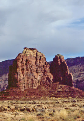
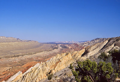
Soon we are down in this broad valley of red rock with canyon walls around us. As we drove we could see in the distance Elaterite Butte the landmark that said we were heading in the right direction. We had eschewed directions from Death-breathe and were depending on the topo map that didn't reflect all the tracks we came across. We headed towards the butte then skirted around the base of it until we came to the Maze overlook.
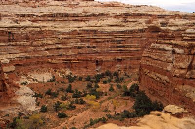 |
| View from Maze Overlook: From Maze (Edited) |
Glenn prepared dinner and afterward we retired. The night was spent on the rim of the canyon in my tent. It was comfortable inside and it was good to spend the night in the warm company of my brother. We reflected on the long day and the remarkable scenery. It had been a great day, the weather was good. We settled into reading our respective books. For me it was Edward Abbey's Down the River, for Glenn it was The River Why by David James Duncan. We read to each other humorous or interesting passages. (I can recommend both books.) The kangaroo rats rustled outside the tent exploring what we may have left them in our camp.
Stepping outside the tent to relieve myself I was confronted with a dazzling splash of stars in the heavens, so sharp and brilliant as to cause me to hold my head aloft to always gaze at them. For this is the last part of the continental US to be mapped. A place so remote that Moab is the only city; next was Hanksville.
Abbey had some nice words for the view...
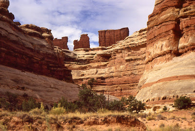
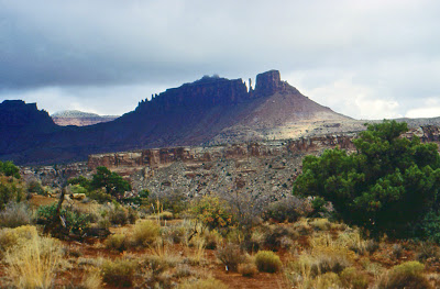
Seven more miles rough as a cob around the crumbling base of Elaterite Butte, some hesitation and backtracking among alternate jeep trails, all of them dead ends, and we finally come out near sundown on the brink of things, nothing beyond but nothingness—a veil, blue with remoteness—and below the edge the northerly portion of The Maze.
We can see deep narrow canyons down in there branching out in all directions, and sandy floors with clumps of trees—oaks? cottonwoods? Dividing one canyon from the next are high thin partitions of nude sandstone, smoothly sculptured and elaborately serpentine, colored in horizontal bands of gray, buff, rose and maroon. The melted ice-cream effect again—Neapolitan ice cream. On top of one of the walls stand four gigantic monoliths, dark red, angular and square-cornered, capped with remnants of the same hard white rock on which we have brought the Land Rover to a stop. Below these monuments and beyond them the innumerable canyons extend into the base of Elaterite Mesa (which underlies Elaterite Butte) and into the south and southeast for as far as we can see. It is like a labyrinth indeed—a labyrinth with the roof removed.
Very interesting. But first things first. Food. We build a little juniper fire and cook our supper. High wind blowing now—drives the sparks from our fire over the rim, into the velvet abyss. We smoke good cheap cigars and watch the colors slowly change and fade upon the canyon walls, the four great monuments, the spires and buttes and mesas beyond.
 Google Earth View of the Maze
The next morning Glenn and I load up our packs and head down the trail. At first easy to find; but as it plunges over the rimrock we find it gets lost as trails do on the slickrock. The trail had a habit of following a strata until a breach is found and it can descend to the next layer. We brought no rope (unlike Abbey) and were confounded by the trail ending at a rock face. Looking closer we could see that there was a rough ledge for ones feet and places to grab with your hands that would allow us to inch our way along this edge of cream colored sandstone cliff. Some hundred feet over the canyon bottom, the drop was surely fatal.
Without packs it looked possible; with packs it wasn't clear you could hold on. Cursing the lack of ropes we managed to tie our belts together. I would go around the cliff face, Glenn would pass me the belt end attached to my pack and I would haul my pack around. I pressed myself against the rock face put my hands onto the upper ledge and began incing my feet along the lower ledge. Unlike Glenn I am cursed with a fear of heights, I cannot look down and have frozen on rock faces before. The great thing about traveling with Glenn however is his coolness and his level headed advice. He guided me as I worked around the edge of the rock. Then with repeated efforts, not without its own danger, I managed to grab hold of the belt end and pull my pack across.
Glenn decided this was all too much work and in typical can-do fashion he traversed the band of cliff face with his pack on and we made it past the difficult section. Soon we were on the sandy canyon floor. The cottonwoods yellow in the fall air and scattered sage and juniper dotting the sides of the dry riverbed.
 |
| View from the bottom towards the Overlook: From Maze (Edited) |
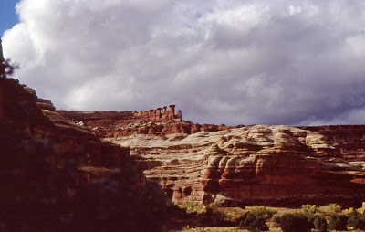
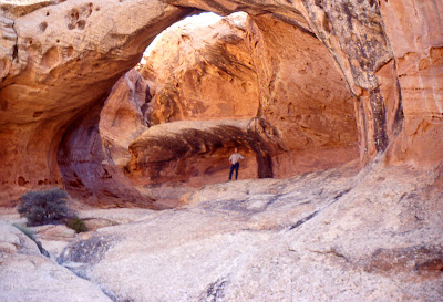
The sandy dry river bed was difficult walking and we looked forward to the places where the trail went overland between the sage and juniper. Looking up the side canyon on our right we could see the Chocolate Drops.
 |
| The Chocolate Drops: From Maze (Edited) |
As we walked along the sandstone walls we noticed pictographs on the wall. Some of them quite high up and most enigmatic. The remnants of some Anasazi work it was impossible to fathom what they meant.
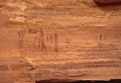 |
| Pictographs: From Maze (Edited) |
Some of the more obvious shapes were snakes, deer or elk (perhaps buffalo?) of some sort, and people expressed as some oddly distorted shapes. They were high up on the canyon walls from a time when the level of the soil was much higher and had been eroded down to where we now stood.
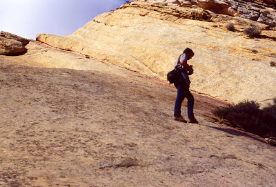
The weather this time of year (November) was cool and quite tolerable. At the height of summer it would have been oppressively hot and we would have been slaves to our water supplies. As I recall we had a vague destination of Lizard Rock at the end of the canyon. This entailed a climb out of the canyon.
We continued hiking the rest of the day on the sandy floor of the canyon taking in the shifting scenes of side canyons and strangely smooth red rock. Finally in the late afternoon we arrived at the end of the canyon. The trail terminated at a series of cliffs and the first of which had a log propped up against it. The idea it seemed was to use this log to aid one as you pushed yourself up the cliff. We made a few tentative attempts but decided to have a more committed attempt in the morning.
By now the weather was starting to turn sour. The clouds that had built all afternoon now looked heavy with rain. We found a nearby overhang and erected the tent underneath it. This would give us a dry camp and kitchen. Glenn started dinner and I wandered about the area and took this photo of him hunched over the stove. This was a familiar sight in camp as Glenn always enjoyed preparing the evening meal and this often meant a unexpected treat in the wilderness.
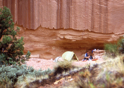 |
| From Maze (Edited) |
Well it rained all night long. Varying from a steady drizzle to much harder downpours. Our sleep
was interrupted by the sound of rocks clattering off of the high cliffs and their soft thump as they landed in the sand. We could also hear water pouring of the normally dry cliffs.
We awoke the next morning to a gray cool day with a steady drizzle of rain. Water poured off of clifftops. Some clear, some stained red revealing that the source was some sandy or clay soil bed or a clean expanse of naked rock. Attempts to now climb the wall at the end of the canyon proved futile as we couldn't get traction on the wet rock and log. Given this we were suddenly concerned about getting past the difficult bit of rock we encountered on the way into the canyon the day before. We decided to head back towards the trailhead and the truck.
We walked back with the wet sand clinging to our boots, marveling now and again at the numerous waterfalls that had appeared overnight.
At the base of the cliff we were stopped by the sight of a deer skull at the base of a cliff. Bits of dessicated meat and skin still clung stubbornly to parts of the skull and we both felt it embodied a sense of mortality and vulnerability. We decided to call it "Death".
Glenn photographed it in black and white with his Hasselblad. Later he printed and mounted the photo for me as a remembrance of the trip. I have always since kept it in my office at work and now it sits on the wall behind me at home here in Bath. During the printing or fixing something went wrong with the chemistry and a kind of orange halo developed around the whitest parts of the image. Rather than ruin the photo it seems to improve it. Below is a photo of it.
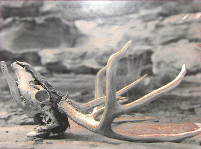 |
| Photo "Death" Glenn Morse From Maze (Edited) |
By the end of the day we found ourselves at the trail out of the Maze and up to the Overlook again. As I remember we found another way back up to the top. The gray clouds had hung low and saturated over our heads all day. As we reached the top we were treated to the magnificent scene of the sun slotting between the low clouds and and the horizon. It cast its deepening light across the tops of the Chocolate Drops and skipped across the lighter tops of the Maze in a brilliant display of light and drama.
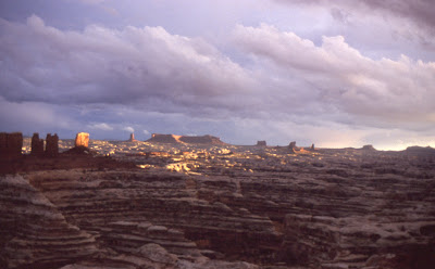 |
| From Maze (Edited) |
Abbey left the canyon in much the way we did. Here is a passage from Desert Solitaire again.
It is now late in the afternoon. We don't have much time left before sundown. Our sleeping bags are up on the rim in the Land Rover and we have nothing to eat but nuts and raisins. We decide it best to climb out of The Maze before dark and save further exploration for tomorrow. We go back to the pool and the base of the ridge. On the way Waterman points out to me the petroglyph of a snake, which I had missed. The Indians had been here. But nobody else, so far as we can tell. Nowhere have we seen a trace of the white man or of his horse or cow—or helicopter. But then we have seen only a tiny corner of The Maze, maybe no more than one percent of it. The heart of it remains unknown.
We climb the ridge, scale the bluffs, and traverse without difficulty the sloping red bench for a mile to the east, where we find the notch that leads to the top through the white rimrock. As we proceed we mark our route with pointer stones; this will be known hereafter, for a thousand years, as the Abbey-Waterman Trail. Maybe. More likely the BLM or the Park Service will bypass our trail with an electrical chair lift for crippled tourists.
We reach the rim a little before sundown and after a quick supper—for it's cold and windy up here—go early to bed. Above the Orange Cliffs a dismal sunset of bloody sun and gray overcast lingers for a long time on the horizon while the wind howls across our prostrate forms all night long.
 |
| From Maze (Edited) |
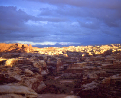
Instead of dinner and bed however, we raced to bring out the cameras to capture this perfect timing of ascent and light. Here is a shot I got of Glenn photographing the canyon.
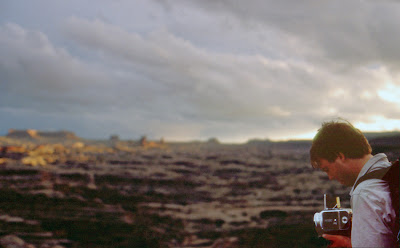 |
| From Maze (Edited) |
We had dinner and slept well that night. Reading again to each other and commenting on the day. Our comments were peppered with concern of getting out up the Flint Trail with so much rain and mud. We consulted maps and found another route out to the west that seemed flatter. Perhaps this would be easier in the mud.
In the morning we struck out on our new planned route. We drove back in the direction of the Flint Trail however we turned left now. We looked back and said goodbye to the Maze District.
 |
| From Maze (Edited) |
The roads were like bacon grease, we slid about on every turn and tilt of the road. The road began to trace its course on a high bench of sandstone; on the right a high set of red cliffs rose above us while another cliff dropped from our left sloping down towards the Colorado River eventually. At times we slipped perilously close to the edge.
 |
| From Maze (Edited) |
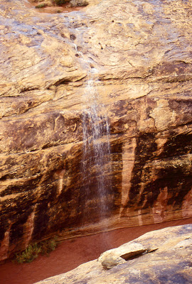
Occasionally we would encounter a stunning exhibit of the weather with a deep red waterfall pouring off the high cliffs above us.
 |
| From Maze (Edited) |
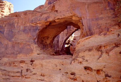
At one point we decided to get out to explore a slot canyon that ran below the road. A muddy stream ran in the bottom. We climbed over the slick rock down into the canyon. We could see fresh water running off the surrounding rocks into the muddy torrent.
 |
| From Maze (Edited) |
Down in this narrow canyon we heard a roar above us. The sound of a passing jet perhaps, we ran to the top again to see it. The sound growing louder we reached the top in time to see a wall of water crashing down the canyon we had just clamored out of. Three feet high it filled the canyon with a fresh angry swirl of red mud.
 |
| From Maze (Edited) |
Ed Abbey witnessed a similar sight in Desert Solitaire.
Around the bend up-canyon poured a red snout of liquid mud, which seemed to mumble to itself as it advanced. Sliding greasily forward the snout of mud dashed against the undercut wall on the outside of the bend, wallowed over ledges and swung back to the main channel in the center of the canyon floor. The clear perennial stream which flowed there was suddenly buried, extinguished. Swaying from side to side in the rhythm of its pendulous momentum, like a locomotive on uneven rails, the flood rumbled down upon the boy and the dead tree and everything else in its path. Dust sailed into the air as it crashed into mudbanks; cracks rippled like lightning over the surface of the alluvium, yawning wide apart as chunks and blocks and sections of dried-out earth slid or toppled into the torrent. On the crest of the flood as it came, above the churning debris of bushes, vines, weeds and logs, floated a delicate and rosy vapor, a fine pink mist suffused with the glow of sunlight.
We drove for 4 and a half hours on dwindling fuel what was slightly over 30 miles of road. The country opened up a little more.
 |
| From Maze (Edited) |
We reached the highway just in sight beyond a river 60 ft wide flowing parallel to the highway. We were stunned and disappointed. Not enough gas to drive back the way we came I asked my brother for his sage opinion. "Go for it!" he barked. I revved the engine and we plowed our way though the high water to safety. We headed to Hanksville for gas.
Next we had to decide what to do with the rest of our time. We decided on Capitol Reef. On the way we spotted a couple of double/triple arches on a topo map and drove out to them.
 |
| From Maze (Edited) |
Glenn poses in this one.
 |
| From Maze (Edited) |
And finally at Capitol Reef the white sandstone.
 |
| From Maze (Edited) |
We drove down the Waterpocket Fold on this dirt road. Little did I realize that years later my life would take me to Oregon and I would travel the real I-84 along the Columbia River to another set of outdoors adventures.
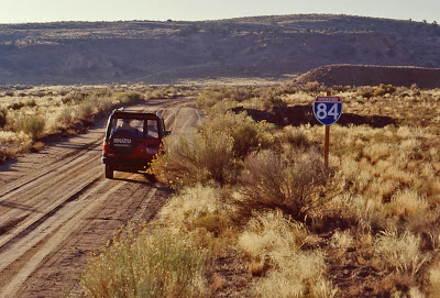 |
| From Maze (Edited) |
 |
| Waterpocket Fold. From Maze (Edited) |
We hiked on the other side of the Waterpocket Fold just above Muley Twist Canyon.
 |
| Glenn with Camera. From Maze (Edited) |
We spent the night in Capitol Reef campground before we had to drive back to Arizona.
This is one of my treasured memories of my brother.
Comments
Mark Rozema