California Vacation
Redington and I went on our annual (since my divorce) summer vacation. We traveled for two weeks in California visiting natural wonders, national parks, friends, and family. The last week we spent with our good friends the Kings. At the end of trip I would drop Redington off at LAX with his mother to fly over to her new home in England. (remember to click the pictures and maps for more detail.)
The first day we drove south and visited Oregon Caves National Monument near the Oregon/California border. Redwoods is in the vicinity of Crescent City famous for a tsumani in the 1950's.

Oregon-California Border

Redington at Oregon Caves
The most striking thing one notices when you arrive is the lodge and visitor center siding is the bark of redwoods. It is a striking unique look to the buildings. It is a wonder it hasn't caught on somewhere else.

The Unique Redwood Bark Siding

Inside the Caves
Then we went to spend the night in Redwoods National Park on the coast of northern California.
Unfortunately we couldn't find a campsite in Redwoods so we drove inland from Arcata to the Six Rivers National Forest home of the mighty Trinity River system near Willow creek. For me this was bit of a pilgramage as I spent years reading about western water conflicts and the Trinity was one of the many rivers in play to satiate the thirst of Southern California. Fortunately the Trinity was preserved though the Sacramento and Feather rivers were dammed and diverted. These rivers too, I would encounter on this journey.

Trinity River
Much to my delight I discovered Port Orford Cedars were to be found in the area and I believe I located a small one. Port Orfords are an extremely rare cedar that exists in a small area of the Oregon and California coastal mountain ranges and strangely enough in Japan. In Japan the wood was reserved for the building of temples. Like other cedars it is rot resistant, soft, and easy to work; the same reasons the more numerous red cedar was considered sacred by northwest indian tribes. The wood also has a rich spicy smell unlike any of the other cedars. Alas there is a root fungus epidemic which may cause the Port Orford to go the way of the Dutch Elm.
The next day we went to Mt Lassen National Park via Redding. A heat wave was on and Redding expected 107 degrees that day; incentive enough to keep moving towards the mountains again. I frankly didn't expect much from this park whose main claim to fame was usurped by the May 1980 eruption of Mt St Helens. I was glad to find a rich diverse forest (Oregon and Flagstaff forests are comparative monocultures) of pine, spruce, fir, redwoods, sugar pines (with gigantic cones), and several types of deciduous trees.

Mt Lassen and ice-bound Lake
The park also boasted a set of geothermal pools which Redington and I hiked to. These would have been quite respectable in Yellowstone. No geysers though.

Hike to the Bumpass Thermal Basin

Mudpot (click picture for video, it takes a while to load...)

Boiling Lake

Fumarole with Sulfur Deposits
In camp Redington entertained himself making traps for Chipmunks. Baiting them with granola bars. He caught one but it escaped.

Redington Trapping a Chipmunk
Lassen is definitely worth the detour if you find yourself in the Redding CA area.
Having spent the night there we next headed further south towards Lake Tahoe. This area between Lassen and Tahoe is richly forested and meadowed. We drove past Lake Almanor and throught the small porposerous townof Quincy. Full of ranches and second homes the country is impossibly big and beautiful. It is Ponderosa Ranch country from the TV show Bonanza and has the connection to myth. In one meadow we saw cowboys rounding up calves using their horses and border collies. The scene could have been one from 150 years ago.

Mt Lassen to Lake Tahoe
The Lake Tahoe and Truckee area was our wakeup call that we were in California. Crowded with traffic, second homes, and the beatiful people it was jarring and somewhat upsetting as I had not anticipated this until further south.

Lake Tahoe
We spent a hot night in a cheap motel in Southe Lake Tahoe while Redington got his quota of TV and I got to shower.

South Lake Tahoe to Mono Lake and Yosemite
Early the next morning we headed out over the passes of the northern Sierras toward the basin and range country of eastern California and Nevada. We went from South Lake Tahoe through Markeeville then Monitor pass at slightly over 8000 ft; as lonely a road as you could wish for.

Monitor Pass
This took us to highway 395 which runs down the east side of the Sierras. With a view of the Sierra Nevadas to our right and sage-scrub lands of the basin and range country to our right we headed towards Mono Lake and Yosemite National Park. We stopped briefly in Bridgeport where we paid the high price of the trip for gas at $3.20 per gallon and heard first word of the second set of terrorist attacks in London.

Sierra Nevada Mountains from Bridgeport
We entered Yosemite from the Tioga pass which I hadn't been on since a trip to California with my uncle Chuck when I was 15 years old. The pass is almost 10,000 ft high and there is ample evidence of the wet winter with high snow banks all around. We enquired about camping spots and learned they were all full in the valley by 10:00 AM even on a Thursday. So we headed for Yosemite creek about 5 miles from the main road via a very bad side-road. There we found a place to camp, claimed it and headed for the valley.
Yosemite valley was hot and crowded, the summer crowds are normal but the heat wave was still on. Parking was nearly non-existent and we took a shuttle bus to the visitor center. From there we walked to the base of the Yosemite falls. This is where the river that runs by our campsite ends up some six miles down stream.
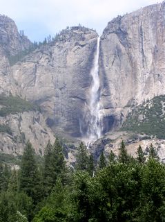
Yosemite Falls

Doug at Yosemite Falls
It was a hot walk to the falls and there were many people in the river below the falls cooling off.
We decide to not spend too much time in the valley due to the conditions there. On the way back up to our much cooler campsite we stopped at the Tuolumne Grove of Sequoia trees. A 1.5 mile hike down to them allowed us to stand, jaws agape at some truly big trees. That is saying something coming from Oregon. There aren't many and these massive groves are scattered in only a few places in the Sierras. Early lumberjacks took it as a challenge to cut them down. They managed to get about 40% of them before someone thought better of it. Age of the trees is a 2-3 thousand years.

Redington at Tuolumne Grove
We headed back to camp to relax, fix dinner, and build a fire. We decided to leave early the next morning, as we had a long way to drive to Death Valley, and left before sunrise. Turned out to be a great idea. The moon was just past full and bathed the rocks in a ghostly white as we drove out. We caught the sunrise at Tioga Pass.

Sunrise-Moonset over Tioga Pass

Sunrise at Tioga Pass

Yosemite to Death Valley
We then drove from Tioga Pass to the Owens River valley. Another saga of Los Angeles' desire for more water. At the turn of the century William Mulholland built the Los Angeles aqueduct to transport water that had been obtained surreptisiously from Owen's Valley farmers. (The aqueduct actually appears n the next map.) In one story a worker was trapped in a tunnel cave-in. While they dug him out they rolled hard-boiled eggs down a pipe to him. Mulholland docked the cost of the eggs from the man's paycheck.

Owens Valley
This is grand country but quite dry except for the the rivers running off the back side of the Sierras. Mary Austin grew up in the small town of Independence and wrote her story "Land of Little Rain" about life and the conflicts of making a living in this area. She later became a close friend of my great uncle Frank Applegate. I was reminded of all this when I stumbled upon her house in Independence.

Mary Austin Home

Independence, CA
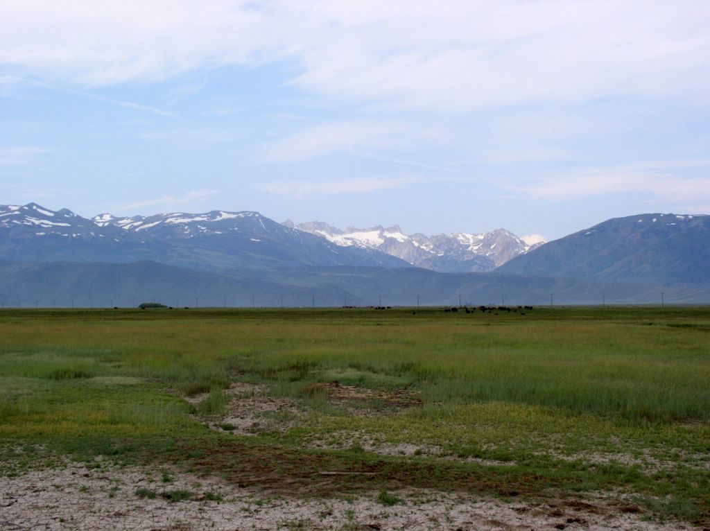
There are no bad views as one drives through Big Pine to Lone Pine. Finally though we have to divert our course toward Death Valley. We encounter first the Panamint Valley that itself leaves the impression it is all of Death Valley. It is but a foretaste of the dry lakebeds, arid wind, and steep moutains.
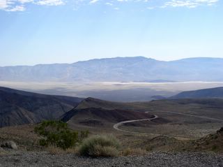
Panamint Valley Death Valley NP
Once in the valley itself it is clear we will not be camping tonight. 129 degrees and a steady 15 mph breeze theatens to dry one out in a matter of hours. Redington and I took to using the term husk as a verb. "The wind would husk you in no time at all." It granted the sense that one would dessicate and blow away if one stayed out too long. We managed a motel room at Furnace Creek without a reservation which shouldn't be a surprise except that the motel fills up most nights as does another at Stovepipe Wells. We were the only English speaking guests as far as I could tell. Lots of German families. Very curious.
While waiting for our room we visited Devil's Golf Course on the dry lake bed. It consists of salt formations which taste very salty and are blindingly white. With the temperature and wind you could hear an eerie tinny noise of crystals breaking.

Devils Golf Course

Badwater Basin
We drive to Badwater Basin which is the lowest point in the US.

Sunrise in Death Valley
In the morning we rose before sunrise for the drive out. As Redington slept in the car I renewed my love affair with the desert. Watching the soft light of the sun, the subtle colors of the hills and vegatation, the optical clarity of the air.

Petroglyphs
I happened to notice some unmarked petroglyphs on a nearby canyon wall and walked in the cool morning air to them. The air smelled richly of the pungent sage and creosote like some exotic market but with a cleanliness that said desert to me. The desert is above all to me clean but by no means sterile.
Death Valley to San Bernardino
We drove out ot death valley to the town of Ridgecrest for breakfast. Ridgecrest appears to exist only to service the nearby China Lake weapons testing ground. Most major aerospace companies are represented here along with miles of chain link fence.
We weren't scheduled to arrive in San Diego for another day a half. I had miscalculated in my plans though. The only places to camp were the desert, too hot, or the mountains, too full on the weekend. The San Gabriel and San Bernardino mountians would be too full of Los Angelinos out to avoid a hot weekend. So I called the Kings and got the go ahead to come down early. This is what Redington wanted anyway as he asked constantly when we would see the Kings.
On the way down we had a flat tire which was the biggest adventure on the trip.
San Bernardino to San Diego
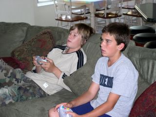
Redington and Conor Playing Video Games

Liam and Michaela
We had a very relaxing visit with Kings. Sitting by the pool, swimming, the kids playing airsoft and video games. Redington and I went booggie boarding with my cousin Gayle. Later that same day I took Jeff, his two oldest kids, Redington, and a friend of theirs skeet shooting. We had a very good time of it. The kids were safe and very upbeat. It was great to see them encouraging each other.
Saturday morning we had to leave. We left at 8:00AM for Low Angeles, I dropped off Redington with his mother at the airport. He was to fly back to her new home to live with her. It was one of the saddest things I have done. I got in my truck for the long drive home. It was good to be alone with my thoughts as I drove out of the LA basin past where waters of the Owens River and Mono lake tumble down the Tehachapi mountains to quench the thirst of LA. Past the Tejon Ranch where Mary Austin once worked. Following the California Aqueduct where the waters of the Sacramento and Feather Rivers flow to LA. Thinking that our lives are sometimes compelled to flow in directions we do not wish.
The first day we drove south and visited Oregon Caves National Monument near the Oregon/California border. Redwoods is in the vicinity of Crescent City famous for a tsumani in the 1950's.

Oregon-California Border

Redington at Oregon Caves
The most striking thing one notices when you arrive is the lodge and visitor center siding is the bark of redwoods. It is a striking unique look to the buildings. It is a wonder it hasn't caught on somewhere else.

The Unique Redwood Bark Siding

Inside the Caves
Then we went to spend the night in Redwoods National Park on the coast of northern California.
Unfortunately we couldn't find a campsite in Redwoods so we drove inland from Arcata to the Six Rivers National Forest home of the mighty Trinity River system near Willow creek. For me this was bit of a pilgramage as I spent years reading about western water conflicts and the Trinity was one of the many rivers in play to satiate the thirst of Southern California. Fortunately the Trinity was preserved though the Sacramento and Feather rivers were dammed and diverted. These rivers too, I would encounter on this journey.

Trinity River
Much to my delight I discovered Port Orford Cedars were to be found in the area and I believe I located a small one. Port Orfords are an extremely rare cedar that exists in a small area of the Oregon and California coastal mountain ranges and strangely enough in Japan. In Japan the wood was reserved for the building of temples. Like other cedars it is rot resistant, soft, and easy to work; the same reasons the more numerous red cedar was considered sacred by northwest indian tribes. The wood also has a rich spicy smell unlike any of the other cedars. Alas there is a root fungus epidemic which may cause the Port Orford to go the way of the Dutch Elm.
The next day we went to Mt Lassen National Park via Redding. A heat wave was on and Redding expected 107 degrees that day; incentive enough to keep moving towards the mountains again. I frankly didn't expect much from this park whose main claim to fame was usurped by the May 1980 eruption of Mt St Helens. I was glad to find a rich diverse forest (Oregon and Flagstaff forests are comparative monocultures) of pine, spruce, fir, redwoods, sugar pines (with gigantic cones), and several types of deciduous trees.

Mt Lassen and ice-bound Lake
The park also boasted a set of geothermal pools which Redington and I hiked to. These would have been quite respectable in Yellowstone. No geysers though.

Hike to the Bumpass Thermal Basin

Mudpot (click picture for video, it takes a while to load...)

Boiling Lake

Fumarole with Sulfur Deposits
In camp Redington entertained himself making traps for Chipmunks. Baiting them with granola bars. He caught one but it escaped.

Redington Trapping a Chipmunk
Lassen is definitely worth the detour if you find yourself in the Redding CA area.
Having spent the night there we next headed further south towards Lake Tahoe. This area between Lassen and Tahoe is richly forested and meadowed. We drove past Lake Almanor and throught the small porposerous townof Quincy. Full of ranches and second homes the country is impossibly big and beautiful. It is Ponderosa Ranch country from the TV show Bonanza and has the connection to myth. In one meadow we saw cowboys rounding up calves using their horses and border collies. The scene could have been one from 150 years ago.

Mt Lassen to Lake Tahoe
The Lake Tahoe and Truckee area was our wakeup call that we were in California. Crowded with traffic, second homes, and the beatiful people it was jarring and somewhat upsetting as I had not anticipated this until further south.

Lake Tahoe
We spent a hot night in a cheap motel in Southe Lake Tahoe while Redington got his quota of TV and I got to shower.

South Lake Tahoe to Mono Lake and Yosemite
Early the next morning we headed out over the passes of the northern Sierras toward the basin and range country of eastern California and Nevada. We went from South Lake Tahoe through Markeeville then Monitor pass at slightly over 8000 ft; as lonely a road as you could wish for.

Monitor Pass
This took us to highway 395 which runs down the east side of the Sierras. With a view of the Sierra Nevadas to our right and sage-scrub lands of the basin and range country to our right we headed towards Mono Lake and Yosemite National Park. We stopped briefly in Bridgeport where we paid the high price of the trip for gas at $3.20 per gallon and heard first word of the second set of terrorist attacks in London.
Sierra Nevada Mountains from Bridgeport
We entered Yosemite from the Tioga pass which I hadn't been on since a trip to California with my uncle Chuck when I was 15 years old. The pass is almost 10,000 ft high and there is ample evidence of the wet winter with high snow banks all around. We enquired about camping spots and learned they were all full in the valley by 10:00 AM even on a Thursday. So we headed for Yosemite creek about 5 miles from the main road via a very bad side-road. There we found a place to camp, claimed it and headed for the valley.
Yosemite valley was hot and crowded, the summer crowds are normal but the heat wave was still on. Parking was nearly non-existent and we took a shuttle bus to the visitor center. From there we walked to the base of the Yosemite falls. This is where the river that runs by our campsite ends up some six miles down stream.

Yosemite Falls

Doug at Yosemite Falls
It was a hot walk to the falls and there were many people in the river below the falls cooling off.
We decide to not spend too much time in the valley due to the conditions there. On the way back up to our much cooler campsite we stopped at the Tuolumne Grove of Sequoia trees. A 1.5 mile hike down to them allowed us to stand, jaws agape at some truly big trees. That is saying something coming from Oregon. There aren't many and these massive groves are scattered in only a few places in the Sierras. Early lumberjacks took it as a challenge to cut them down. They managed to get about 40% of them before someone thought better of it. Age of the trees is a 2-3 thousand years.

Redington at Tuolumne Grove
We headed back to camp to relax, fix dinner, and build a fire. We decided to leave early the next morning, as we had a long way to drive to Death Valley, and left before sunrise. Turned out to be a great idea. The moon was just past full and bathed the rocks in a ghostly white as we drove out. We caught the sunrise at Tioga Pass.

Sunrise-Moonset over Tioga Pass

Sunrise at Tioga Pass

Yosemite to Death Valley
We then drove from Tioga Pass to the Owens River valley. Another saga of Los Angeles' desire for more water. At the turn of the century William Mulholland built the Los Angeles aqueduct to transport water that had been obtained surreptisiously from Owen's Valley farmers. (The aqueduct actually appears n the next map.) In one story a worker was trapped in a tunnel cave-in. While they dug him out they rolled hard-boiled eggs down a pipe to him. Mulholland docked the cost of the eggs from the man's paycheck.

Owens Valley
This is grand country but quite dry except for the the rivers running off the back side of the Sierras. Mary Austin grew up in the small town of Independence and wrote her story "Land of Little Rain" about life and the conflicts of making a living in this area. She later became a close friend of my great uncle Frank Applegate. I was reminded of all this when I stumbled upon her house in Independence.
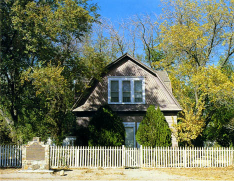
Mary Austin Home

Independence, CA
There are no bad views as one drives through Big Pine to Lone Pine. Finally though we have to divert our course toward Death Valley. We encounter first the Panamint Valley that itself leaves the impression it is all of Death Valley. It is but a foretaste of the dry lakebeds, arid wind, and steep moutains.

Panamint Valley Death Valley NP
Once in the valley itself it is clear we will not be camping tonight. 129 degrees and a steady 15 mph breeze theatens to dry one out in a matter of hours. Redington and I took to using the term husk as a verb. "The wind would husk you in no time at all." It granted the sense that one would dessicate and blow away if one stayed out too long. We managed a motel room at Furnace Creek without a reservation which shouldn't be a surprise except that the motel fills up most nights as does another at Stovepipe Wells. We were the only English speaking guests as far as I could tell. Lots of German families. Very curious.
While waiting for our room we visited Devil's Golf Course on the dry lake bed. It consists of salt formations which taste very salty and are blindingly white. With the temperature and wind you could hear an eerie tinny noise of crystals breaking.

Devils Golf Course
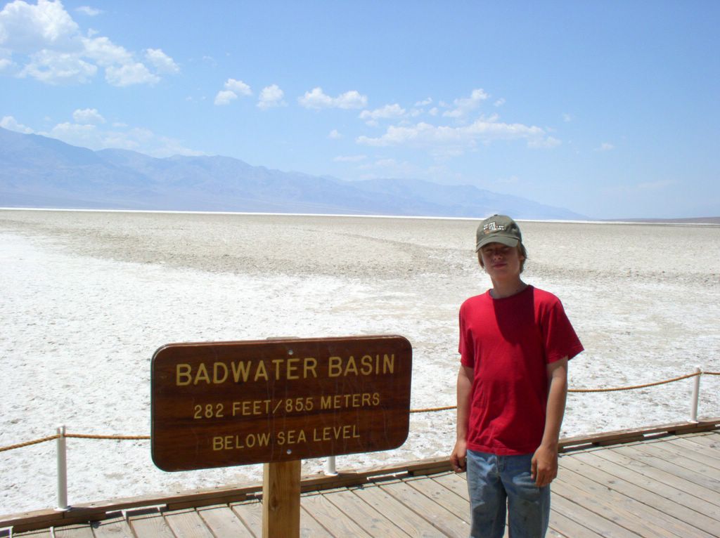
Badwater Basin
We drive to Badwater Basin which is the lowest point in the US.

Sunrise in Death Valley
In the morning we rose before sunrise for the drive out. As Redington slept in the car I renewed my love affair with the desert. Watching the soft light of the sun, the subtle colors of the hills and vegatation, the optical clarity of the air.

Petroglyphs
I happened to notice some unmarked petroglyphs on a nearby canyon wall and walked in the cool morning air to them. The air smelled richly of the pungent sage and creosote like some exotic market but with a cleanliness that said desert to me. The desert is above all to me clean but by no means sterile.

Death Valley to San Bernardino
We drove out ot death valley to the town of Ridgecrest for breakfast. Ridgecrest appears to exist only to service the nearby China Lake weapons testing ground. Most major aerospace companies are represented here along with miles of chain link fence.
We weren't scheduled to arrive in San Diego for another day a half. I had miscalculated in my plans though. The only places to camp were the desert, too hot, or the mountains, too full on the weekend. The San Gabriel and San Bernardino mountians would be too full of Los Angelinos out to avoid a hot weekend. So I called the Kings and got the go ahead to come down early. This is what Redington wanted anyway as he asked constantly when we would see the Kings.
On the way down we had a flat tire which was the biggest adventure on the trip.

San Bernardino to San Diego

Redington and Conor Playing Video Games

Liam and Michaela
We had a very relaxing visit with Kings. Sitting by the pool, swimming, the kids playing airsoft and video games. Redington and I went booggie boarding with my cousin Gayle. Later that same day I took Jeff, his two oldest kids, Redington, and a friend of theirs skeet shooting. We had a very good time of it. The kids were safe and very upbeat. It was great to see them encouraging each other.
Saturday morning we had to leave. We left at 8:00AM for Low Angeles, I dropped off Redington with his mother at the airport. He was to fly back to her new home to live with her. It was one of the saddest things I have done. I got in my truck for the long drive home. It was good to be alone with my thoughts as I drove out of the LA basin past where waters of the Owens River and Mono lake tumble down the Tehachapi mountains to quench the thirst of LA. Past the Tejon Ranch where Mary Austin once worked. Following the California Aqueduct where the waters of the Sacramento and Feather Rivers flow to LA. Thinking that our lives are sometimes compelled to flow in directions we do not wish.
Comments